ALIVE RIVER – Episode 5: Rivers in the Water Cycle
In the previous episode, we explored the Eurasian beaver – a master engineer whose dams reshape water flow and create new habitats. This time, we take a step back and look at the bigger picture: how water circulates through our landscape and what role rivers play in this cycle.
Rivers are dynamic natural systems in which water, sediment, and energy continuously move through the landscape. Their form, flow, and functioning result from the interplay of climate, geological substrate, relief, vegetation, and human interventions. Through processes of erosion, sediment transport, and deposition, rivers shape the Earth’s surface, create habitats, and connect different parts of a catchment into a unified hydrological system. As physical phenomena, they are shaped by hydrological, geomorphological, and hydraulic processes that vary across space and time and determine the development of riverine environments, including the river channel, banks, and floodplains.
The Water Cycle
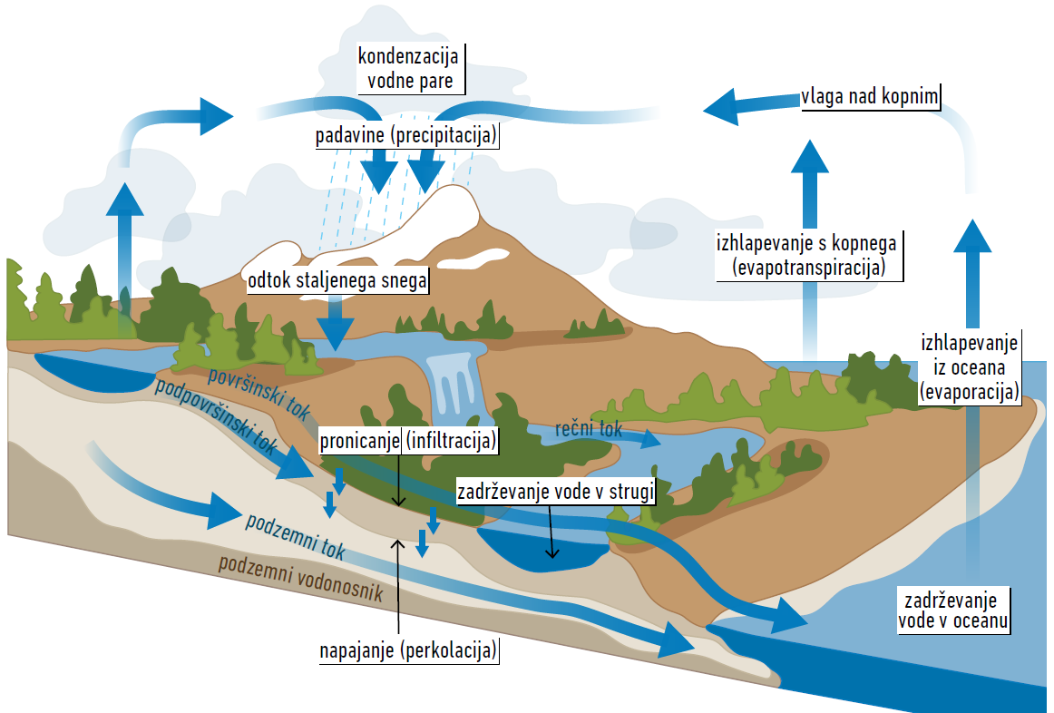
The water cycle is a conceptual model that describes where water is found on Earth, in what forms it appears, and how it circulates between different parts of the environment. Water is constantly redistributed between oceans, the atmosphere, and land through various hydrological processes (Figure 1). The water cycle includes numerous pathways of water movement and storage areas such as soils, aquifers, glaciers, oceans, the atmosphere, and the biosphere. The total amount of water on Earth remains constant – water does not appear or disappear; only its physical state and spatial distribution change.
Hydrological Processes
Precipitation is the hydrological process people most often discuss, as it directly affects our daily lives. Precipitation results from the condensation of water vapor due to cooling – in other words, rainfall, snowfall, hail, and sleet, which originate from clouds formed in the atmosphere, or phenomena that form directly at the surface such as freezing rain, dew, frost, and rime.
Water that absorbs heat evaporates from the surface back into the atmosphere. Evaporation occurs either directly from soil and water surfaces (evaporation) or through plant stomata (transpiration). Evaporation from land is therefore often collectively referred to as evapotranspiration. A smaller portion of atmospheric water vapor also comes from sublimation, the direct transition of snow from solid to gaseous state.
Water in liquid form flows across Earth’s surface due to gravity, moving from higher to lower elevations as surface, subsurface, and groundwater flows. Water from land drains into seas and oceans through networks of watercourses. It can also reach the oceans in solid form as glaciers. Subsurface flow occurs when surface water infiltrates the soil and moves through the unsaturated zone (above the groundwater table), while groundwater flow moves through the saturated zone (below the groundwater table).
Infiltration is the process of water entering the soil, while percolation refers to water moving into deeper soil layers (aquifers). Infiltration is influenced by topography, vegetation cover, soil surface roughness, and subsurface soil properties (structure, texture, moisture, and organic matter content).
Hydrological processes in the water cycle are strongly influenced not only by natural factors but also by human activities, land use, and climate change. To understand and predict hydrological processes, we use hydrological modelling.
Before water evaporates back into the atmosphere, it is stored in various places on Earth’s surface, sometimes for extended periods – such storage areas include aquifers, glaciers, snow cover, lakes, seas and oceans, wetlands, and watercourses. An important water reservoir is also the biota, especially vegetation.